

Deep inside southern Portugal, lies the Alentejo region. A land of vast countryside and scorching summers, often seen as a desert by its own country, even though it was once described as the “nation’s breadbasket”. It was home to many different peoples through the years, from the Romans to the Moors and the Christians.
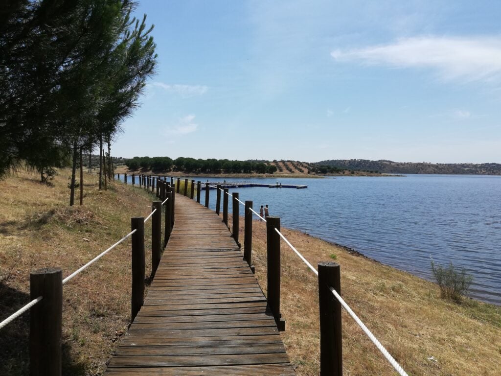
But the Alentejo has changed. Today, it is more of an olive grove than a breadbasket, multiculturalism is now a reality and, most importantly, it is now an oasis, not a desert. And this is thanks to the Great Lake of Alqueva, a dam that took over three decades to conclude and completely reshaped the region.
At the time of its construction, it was Europe’s largest artificial lake, extending for over 250 square kilometers, and encompassing three municipalities and two districts. Its main purpose is energy production and as a water reservoir, but in my opinion, its biggest achievement was creating a beautiful inner sea on a countryside background that is still fairly unexplored by tourism.
It was within this context that a group of previously forgotten villages rose to prominence and presented themselves as quaint, charming options for travelers looking for a truly genuine experience, away from the crowds and right in the middle of the countryside, but with many entertainment options for the adrenaline junkies too.
I’m talking, of course, of Alqueva’s Riverside Villages, a network of sixteen villages located on the shores of the Great Lake, famous for their white houses and red roofs, cobbled streets, with only a few hundred inhabitants each, and with the countryside a stone throw away.
I hail from this region, so it is with a lot of pride and pleasure that I came up with an itinerary that you can complete in a single day or, ideally, during a full weekend to make the most out of it. The route I chose starts at the northernmost village of Juromenha and follows a centripetal, counter-clockwise path before concluding at Monsaraz, the crown jewel of the region.
This guide includes descriptions of each village, suggestions on where to stay for the night, where to eat, when to go, and what to do. It’s as complete as it gets, so make sure to give it a read before you head to the Alqueva Lake, so you don’t miss a thing. Ready? Let’s go.
Juromenha
Our journey starts in the municipality of Alandroal, in Alto Alentejo. Getting there from Lisbon is fairly easy. All you need to do is take the 25 de Abril bridge and follow the A2 highway. After about 40 minutes, switch to the A6 at Marateca towards Évora and just drive all the way until you reach Elvas after around one hour. From there, just take the N373 for less than ten minutes and you should be there.
Juromenha is a Portuguese parish in the municipality of Alandroal with around 100 inhabitants. Located at the northeast end of the municipality, it borders the disputed Territory of Olivença to the southeast. It is the smallest parish in the municipality in terms of area, population, and population density.
It was the seat of a municipality, which was abolished around 1836, and included the parishes of Juromenha and São Brás dos Matos and, in 1801, it had 823 inhabitants. The town of Vila Real, located beyond the Guadiana, administered by Spain since 1801, and part of the municipality of Olivença nowadays, belonged to the municipality and parish of Juromenha.
Juromenha’s origins go back a long way, having held the honorable position of sentinel of the River Guadiana, which flows at its feet. It was conquered by King Afonso Henriques in 1167. It then entered the domains of the Order of Avis, to whom it was donated by King Sancho I. Some important episodes took place there during the 17th-century Restoration War and the 19th-century Peninsular War.
After it was annexed to the municipality of Alandroal, Juromenha began a process of decline, which was accentuated in the 1920s, when the population completely abandoned the area within the walls and the suburbs developed around the hermitage of Santo António, which is today the fundamental nucleus of the town.
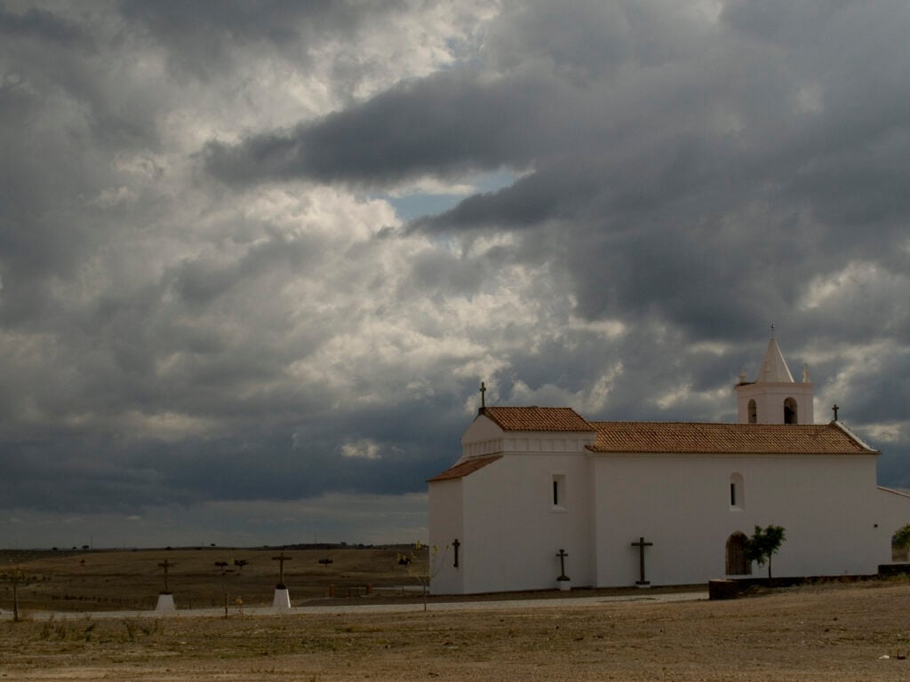
The fortress, which has a polygonal plan, is the village’s highlight. Today, inside the walled enclosure, there are the ruins of two churches, the jail and the old Town Hall. In landscape terms, the old fortress has a privileged location in terms of the visual domain of the Portuguese and Spanish territories.
Capelins
Our trip continues along the N373, which we will follow for about 10 minutes before taking a left toward “Mina do Bugalho”. Then, after 15 minutes, we arrive in the often-overlooked village of Capelins, also known as Santo António.
With nearly 400 inhabitants, it feels like a metropolis in comparison to Juromenha, even though it doesn’t boast a history nearly as impressive. It is not directly overlooking the water, but it is instead surrounded by rolling, green hills that calmly move as the wind blows, creating a very relaxing landscape.
Located on the south-eastern edge of the municipality, the parish of Capelins is bordered by the municipalities of Mourão and Reguengos de Monsaraz to the south – both of which make for great “headquarters” to spend the night during this trip – and Spain to the east.
Until 1836, the parish of Capelins belonged to the extinct municipality of Terena, whose origins are very old, dating back to the 13th century when it was first granted a royal charter. Through its castle, the town of Terena played a very important role in border defense, being, like Monsaraz further south, a point on the Guadiana defense line.
Monte do Trigo
After leaving Capelins behind, you should take a left to the N255 and follow it until you reach Casas Novas de Mares. Right after leaving it, take a right toward Montoito. After crossing Montoito, take the M513 until you reach Vendinha and take a right to the N256. After about 10 minutes, take the IP2 toward São Manços, pass it, and you should find Monte do Trigo on your left after just a few kilometers.
Everything indicates that Monte do Trigo was, in the 13th century, already a very important and fundamental space, both in terms of its geographical location as a distributing node of the road network that served the region and in terms of economic resources, which meant that these lands were not included in the donation made by King Afonso III to the nobles.
In 1283, King Dinis exchanged it for the town of Alvito, which then became the property of the Monastery of the Trinity of Santarém. In the 15th century, part of this reguengo was donated to the Countess of Faro. Subsequently, the whole area became part of the patronage of the House of Bragança.
The original church of the village – whose name literally means “wheat hill” – apparently built in the 16th century, disappeared completely between 1946 and 1947, giving way to the current church, which was built on the same site and is the highlight of the village.
Amieira
From Monte do Trigo, it’s very easy to get to Amieira. Just take the IP2 again and get out at Portel. Then follow the directions to Moura, taking you along the R384. After about 10 minutes, take a left following the indications to Amieira, which will take you back to the N255. You’ll be able to see the village in the distance.
Amieira is a quiet village situated in a valley between the Amieira stream and the Degebe river, it is today a riverside village on the large Alqueva lake that draws crowds during summer thanks to its very pleasant artificial beach.
The word “amieira” or “amieiro“, which means “frequent tree in wetlands”, may be the origin of the name of this parish. The proximity of water from various streams, and especially the River Degebe, would make those lands humid, allowing for an abundance of vegetation, including alder trees. This natural name may have come to identify the place, along with the name given to the parish: Nossa Senhora das Neves da Amieira.
Amieira is home to a Marina that has an incredible restaurant and offers a wide range of nautical products, services, and activities such as river cruises, boat rentals, and water sports.
Alqueva
From Amieira, you’ll need to drive back along the N255 toward Moura. Then take a left, which will bring you back to the R384 and after just a few minutes you’ll reach Alqueva.
The village of Alqueva is part of the municipality of Portel, in the district of Évora. The first references to this village appear in documents from 1285. The name “Alqueva” derives from “alqueive“, which means “fallow land” or “deserted land”, which is due to its very dry and rough soils, which was one of the biggest obstacles to the development of this region.
But it all changed a few decades ago when a proposal was made to build a dam next to the village with the aim of irrigating the soils and bringing development to a region whose main activity was agriculture. The dam is, of course, the Great Lake of Alqueva, which took its name from this village.
Recently, the parish built an artificial beach just outside the village, making it a great spot to park your car and head for a dip in the warm waters of the lake.
Marmelar
You won’t need to switch roads to get to Marmelar. At the roundabout in Alqueva, there are indications for Marmelar and Vidigueira. Just follow that road for 15 kilometers and it should take you there. During this quick ride, you’ll cross from the Alto Alentejo region to the Baixo Alentejo region. See if you can spot the differences in the landscape!
The village, which throughout the years has been part of the municipalities of Beja, then Cuba, and finally Vidigueira, has its origins shrouded in mystery, but some architectural testimonies reveal a very old settlement.
Located on the right bank of the Guadiana, Marmelar has always enjoyed favorable conditions for human settlement, as witnessed by the Corte Serrão dolmens, which tell us about the occupation of this region during the Eneolithic period, when the dead were worshipped through the construction of funerary monuments.
The picturesque Church of Santa Brígida in Marmelar is worth a visit while you’re here. It dates back to the 16th century and it’s a great example of traditional religious architecture in the region.
Pedrogão
Pedrogão is the head of the parish Marmelar is a part of, so it won’t be hard for you to find directions leading you there. The trip from Marmelar to Pedrogão takes less than ten minutes, so just enjoy the warm breeze and the vineyards on your way there.
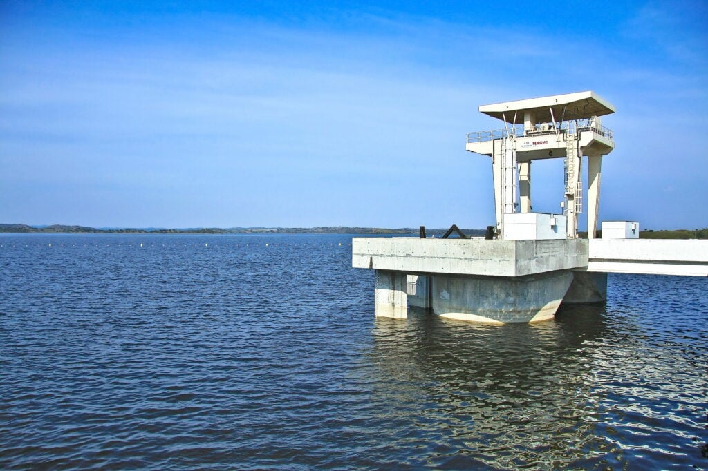
The Pedrógão dam, which is part of the Alqueva development, was built next to this peaceful village in 2006 with the aim of stabilizing the flow of the River Guadiana downstream of the Alqueva dam, to produce electricity and supply water for irrigation, so these lands have since become very fertile, something they didn’t always benefit from.
Even the name “Pedrogão” seems to come from the word “pedra”, which means “rock”. You can still see a lot of rock formations scattered around the village and a lot of those were collected and transported to the nearby Corte Serrão dolmens, which are worth a visit.
Mina da Orada
Back on the N258, cross the wide bridge over the Guadiana, and it’s only five minutes before you see the plaques directing you to Orada. Take the right exit and the village is right ahead.
A village in the parish of Pias, in the municipality of Serpa, Orada is located next to the Pedrógão dam. It’s a small village whose main economic activity was mineral extraction until the mine, located next to the town, was shut down in 1971.
Its main attractions are the Chapel of Nossa Sra dos Prazeres and the old magnetite mine, now flooded, which is a popular place for diving. If you do decide to jump in, make sure you bring company or have spotters since it is actually not allowed – even though locals do it all the time.
The lake of the Orada mine is a very beautiful place, inspiring tranquility as only the Alentejo is capable of instilling, and is a popular spot for locals. According to those who have dived here, diving in the lake is relatively simple with very acceptable visibility and some life to discover. There are several galleries and tunnels that are interconnected. However, entry to the galleries is not recommended for anyone who is not certified for cave diving.
Póvoa de São Miguel
From Orada, you’ll need to get back to the N258 and head toward Moura. This city – where yours truly hails from – is a great place to spend the night and break this itinerary into two legs with eight villages per day. You’ll cross Moura from the west to the northeast, taking the N255 and crossing the River Ardila. Right after the bridge, take a right and switch to the N386 which will take you to Póvoa de São Miguel.
Póvoa de São Miguel is located in the municipality of Moura, on the left bank of the Guadiana River, halfway along the road linking Moura to Mourão. It stands on a high point from where you can see Monsaraz Castle. Next to the village runs the Ribeira do Zebro, which is now a branch of the Alqueva dam.
The village’s origins date back to the end of the 14th century, following the Sesmarias Law, published in 1375 by King Fernando, whose aim was to settle people in the countryside. The black plague ravaged Europe during this period and had a particular impact on the cities, where the mortality rate was very high, causing a shortage of manpower and causing wages to skyrocket. This led to the aforementioned exodus from the countryside to the cities, leaving the fields abandoned with a consequent lack of cereals and other agricultural products in the country.
As a curiosity, the population of Póvoa had, in the 2021 census, 761 inhabitants. The official name of the town was just Póvoa, but for many years it had been known among its inhabitants as Póvoa de São Miguel, in honor of its patron saint, and this name was made official in 1988.
Estrela
Drive across the village, following the directions to Mourão. Following the M517, it’s only a short drive before you see the indication for Estrela to the left, sitting on a peninsula, directly facing the Great Lake.
Due to its exceptional location, an anchorage was built where the boats that cross the Alqueva dam dock. It’s a great place for a stroll, a picnic, or even a swim. It’s also a great place for lunch. Sabores da Estrela was an incredible restaurant, but it recently closed. But this tiny village has other great restaurants, so make sure you try some migas or an açorda.
Granja
You’ll need to drive back to the M517, but only for a few meters. Turn right toward Amareleja/Granja. Follow the road for 15 minutes until you reach the N385, where you’ll take a left and, once again, return to the Alto Alentejo region. Granja is right ahead.
Granja is located next to one of the dam’s branches, the Alcarrache stream. Its heritage includes the Head Church, which stands out from the other houses in the village. Built in the 16th century, it has a rectangular floor plan and a large nave, and its interior contains paintings of great interest. Also noteworthy is the Church of Santa Casa da Misericórdia right in the center of the village.
Historically, little is known about the history of this village, largely due to the constant pillaging by the Spanish during the Restoration War. However, there are references dating back to the 13th century to a “Granja do Hospital”, administered by the regimental order of the Freires do Hospital.
It is, however, known that the Romans and Arabs also inhabited this region, leaving behind bridges over the rivers Alcarrache and Godelim, as well as several Moorish chimneys.
Aldeia da Luz
The N358 will take you across one of the most beautiful bridges you’ll see in Portugal, over the Alqueva Lake. Once you get to Mourão, follow the directions to Estrela/Luz until you find yourself on the M517, where you’ll need to turn right after a while and head southwest until you reach Luz.
No other village is more symbolic than Aldeia da Luz. That’s because this is actually not the original village. The original village lies under the waters of the Alqueva Lake. The new village was built in such a way as to essentially maintain the characteristics of the old village, inch by inch.
The issue of relocating the inhabitants of the village of Luz began in 1981. Three options were considered: compensate the inhabitants, transfer them to a neighboring village, or build a similar village. This last alternative was chosen and was preferred by the population, so construction began in 1998 and finished in 2002.
Today, it is a beautiful village right by the water and its recent construction gives it a very clean and neat look that makes it very unique. The village also has a museum dedicated to preserving the memory of the old village that is definitely worth stopping by.
Campinho
You’ll need to head back to Mourão and this time follow the directions to Reguengos de Monsaraz. This should put you on the N256 and, once again, you’ll drive across a bridge over the lake. If you look to your right, you’ll spot Ilha Dourada, an island with an artificial beach that you can visit by boat. It’s as peaceful as it gets. Once you get to Reguengos, follow the directions to Évora/São Marcos do Campo. Once you get to the N255, follow it until you reach Cumeada, then take a left to the M532 which will get you to Campinho in no time.
An airfield and mooring have been built next to the small village, so it has been the scene of various nautical and aeronautical activities. There is also a picnic area next to the Alqueva reservoir, which is a great place for a peaceful picnic.
At one end of the village is the Sagrado Coração de Jesus Church, built in the 20th century with architectural lines that represent the sobriety and monumentality of the Estado Novo. On the tower, the bells of the Braga Foundry are engraved with the date November 1957.
São Marcos do Campo
São Marcos do Campo is so close to Campinho that you could even walk your way there. It’s just four kilometers along the CM1129 in a nearly straight line.
The village of São Marcos do Campo, with a total of 840 inhabitants, is linked to the bank of the reservoir formed by the river Degebe, and to the village of Amieira on the opposite bank. This village was built in the 13th century.
The Church of São Marcos do Campo was built in the 16th century, with references to it dating back to 1534. In the 18th century, it was completely remodeled and the body of the nave was enlarged.
Telheiro
Get back to Reguengos de Monsaraz and follow the indications to Monsaraz. Once you’re on the M514, follow it for about twenty minutes until you reach Telheiro on the foothill of Monsaraz.
The village of Telheiro is a small settlement in the parish of Monsaraz, which has developed in conjunction with the parish seat. It is located at the base of the hill on which Monsaraz stands, so there is reason to believe it was reserved for the commoners back in the day.
Its main tourist attractions are its fountain dating from the 18th century, as well as several megalithic monuments that demonstrate the occupation of this region in ancient times.
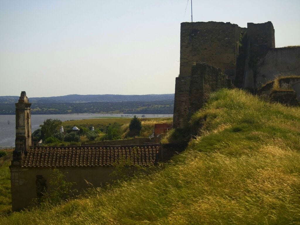
Monsaraz
I don’t think you need any directions given that you can see Monsaraz right ahead. Just go up the mountain, it’s not tricky at all.
Monsaraz lies next to the Guadiana on top of a hill that rises out of Alentejo’s never-ending plains. It was conquered from the Moors in 1167 by Geraldo Sem-Pavor and handed over to the Templars by King Sancho II for defense and settlement.
For centuries, the castle of Monsaraz played the role of a lookout point on the Guadiana, from where the border with Castile could be seen. It was the seat of the municipality until 1838 when this function passed to Reguengos.
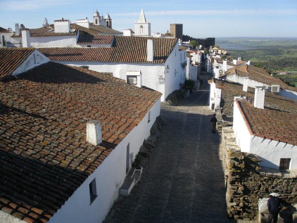
The medieval town of Monsaraz, protected by its walls, is a small village with its schist streets and whitewashed walls. Its narrow streets are full of nooks and crannies and its backdrop is a breathtaking view of the Alentejo landscape and the Alqueva Lake.
Last Thoughts
And with several hotels and restaurants, and a castle you can visit for free, this is the perfect place to conclude our journey through the Alqueva Lake, watching the sunset with a glass of wine and a table full of bread, cheese, cold meats, and olives.
I really hope I was able to convince you to give this region a chance. As a local, I think there is a lot it can offer, and given that it’s fairly out of hand, it’s never too crowded, making it the perfect place for a pleasant and peaceful 2 or 3-day weekend.
As for the best time to come, the Alentejo is great year-round. In winter, it’s not too cold and not too rainy either. And by the end of December, you usually get very sunny days. Spring is usually a fan favorite, but March and April are quite unpredictable when it comes to the weather. May and June, while the temperature is getting warmer are great months to visit. July through September are great too, especially since there are many artificial beaches scattered around the region, so you get to escape the scorching heat.
But, whenever you decide to visit, I hope you have a great time!
